The core of BIOPRESS consists of two closely linked but consecutive phases: Phase-I which aims at characterising land cover change in and around a representative stratified sample of Natura 2000 sites and Phase-II which aims at linking the measured land cover changes to pressures on biodiversity (see figure 1).
This will be achieved by means of
8 Work Packages. |
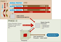
 Figure 1. Schematic of the project’s major work and research components. Figure 1. Schematic of the project’s major work and research components. |
Phase - I , characterising land cover change (1950-2000) in and around Natura 2000 sites:
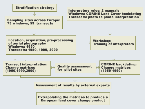
The land cover change statistics are produced by means of two parallel activities:
• The backdating of CORINE land cover 1990 of circa 75 windows (30km x30km) with aerial photography of the 1950'ies. The windows are interpreted to identify the CORINE level 3 land cover and use classes to a minimum mapping unit of 25 ha.
• The interpretation of aerial photography from 1950, 1990 and 2000 for circa 59 transects (2km x15km). The transects are located inside windows and interpreted to a minimum mapping unit of 0.5 ha. A subset of the transects are also interpreted for linear and point features such as hedges, small streams and cluster of houses.
Phase – II, Linking land cover change to pressures on biodiversity using a Pressure State Impact framework.
The main focus is on the relationship between land cover change and 6 key pressures: urbanisation, afforestation, deforestation, abandonment, intensification (arable) and drainage. The team's efforts is subdivided into 5 work packages:
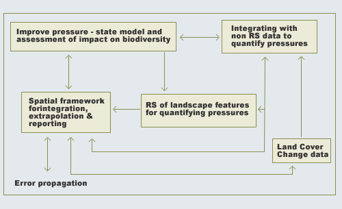
• One work package aims at describing and predicting the consequences (impact) of the observed land cover changes (state) and pressures on biodiversity.
• A second work package will investigate the causes (pressures) of the observed land cover changes (state). Since there is not always a direct relationship between land cover changes and pressures, indicators of socio-economic processes will be used. The work will involve setting up a strategy for selecting indicators suitable for specific presures and designing a generic model for data integration to quantify these pressures.
• A GIS framework will be developed to support data extrapolation and facilitate data integration within realistic and appropriate regions.
• The propagation of error between the different stages of data processing and integration will be investigated.
• Improved automated methods for detecting changes in land cover and landscape features from multi-scale remotely sensed data will be developed and tested.