Park Management
Management of the Park's Action Program
Outline
Implementation of the management module for the Action Program came about gradually for Vulcanus. The part corresponding to management of mandatory reports drawn up by the Park was designed and implemented during a first phase. Reports in the 'Zona Volcŕnica de la Garrotxa' context are a prerequisite for permission granting (forest cuts, road opening, etc.) and take the form of written documents and accompanying maps, spreadsheets, etc. Over 90% of the Park's area is privately owned. Once that was done, a part concerning the control of offenses was developed following the design scheme detailed below. During the last stage of implementation for this module, the most important step was finally taken, which was to incorporate the whole control of the Natural Park's entire Action Program. Management of reports and offenses is only a part of this Action Program, which includes all other actions carried out by the park (remodeling projects, studies, etc.)
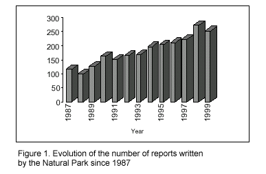
The example of Natural Park report management illustrates the need for this module. As shown in Figure 1, the number of reports drawn up by the Natural Park has increased over the years, representing an ever-greater percentage of time spent by Natural Park personnel.
Every one of the hundreds of reports written in one year contain geographical information on the report's location, as well as one or more associated documents describing the resolution of it (maps, text documents, spreadsheets, databases, pictures, etc.). It became increasingly more important to control and organize all this information in order to make it easy to locate and access. Vulcanus offers the appropriate setting to carry out this task with computers.
For a more detailed description, see the correspondingarticle.
Goal and objectives
The goal of this module is to make available to Natural Park personnel permanent, updated digital cartography on actions scheduled in the Natural Park's own Action Program. This cartography would also let the Action Program to be followed up from any of the Park's computers.
The objectives to be reached are:
Design and Implementation
The following is an outline of the part corresponding to the design of reports management included in the Action Program management module. The part corresponding to offenses and the rest of the Action Program is described here, but its design and implementation are similar to those explained for the reports.
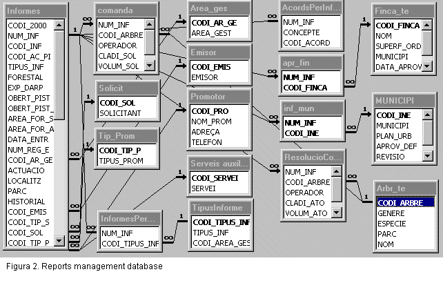
First of all, a relational database (Fig. 2) was built to gather all information needed to define a mandatory report (entry and exit register numbers, entry and exit dates, title, location, originator, issuing agent, area of park management, etc.).
A set of forms was implemented for data entry and for maintaining and editing the database. Figure 3 shows the part of the forms corresponding to entry and exit of reports to and from the Park. These forms, together with the lists defined in the database, allow for tight control over all information that enters the database, to make sure it is correct and maintains internal coherence.

This data entry application also gives the code that is to be assigned to the report, according to the values entered in the database. Drawn up according to pre-established criteria, this code is also the name of the document making up the report and the code assigned to digitized graphical elements, which represent the location of the action reported. Graphical elements are related to the database by means of this and thus access from the graphical object to the database is given. By just clicking with the mouse on a report in the map of Park reports access all its database information is provided.(see Fig. 4).
As it can be seen in the red box (Fig. 3) of the form corresponding to report exits (Fig. 3), the database also lets you store information regarding the map drawn up for the report as well as other documents associated with the report. These database fields store the name of the file of each document that has been produced (map, text document, etc.). The file name contains the specific address of the file on the disk.
All this information contained in the database and entered by means of the forms can be accessed from the report map viewed with the GIS (Fig. 4 shows a detail of the map). By clicking on any graphical element access not only to data on reported actions contained in the database, but also to the documents making up the report (MiraMon map, text document, etc.) which are located in the server folder is given. Figure 4 shows how a simple locating query can give you access to the map and document generated by a particular report.
In regard to offenses and the other actions controlled from the Natural Park Action Program, a similar design and implementation is followed. This lets you access from any computer in the Natural Park all the graphic, alphanumeric and document databases related to reports, offenses, works, studies, etc. This allows for tight control over not only the activities of the Natural Park itself, but also over events that occur in the territory and their locations.
