|
 |
Park Management
Legislation and Territory
Outline
Conservation of a protected area is based, in the end, on the legislation established for that purpose and which regulates the territory. In the case of Catalonia, this involves everything from sectorial legislation (forest, water, etc.) to rules governing to urban planning (Urban Planning General Plans, etc.). In the case of the 'Zona Volcŕnica de la Garrotxa' Natural Park, where there is a high level of human activity, it is imperative to be aware of which regulations govern each point of the territory in order to achieve proper management of the Natural Park. Given the number of laws, decrees, etc. that must be taken into account, including the knowledge of how they are applied at each point and area of the territory, it is obvious how useful a system offering direct access to these regulations from GIS maps would be to the Park personnel who have to make decisions based on these regulations. This is exactly what the module explained here is intended to do: offer access from Vulcanus's maps to legislation that regulates each point or area of the Natural Park.
Goal and objectives
The goal of this module is to digitize, structure and organize all cartographic information related to Park regulations and offer the possibility of directly accessing the particulars of legal texts from a GIS environment.
The objectives to be achieved are:
Design and Implementation
As an example of implementing this module, the following is an explanation of the particular case of urban planning in the district of Olot.
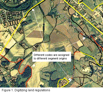
In the first place, and if information is not available in digital format, planning boundaries must be digitized. This case outlines the boundaries of land that can not be urbanized according to the Urban General Plan of Olot. In order to do so, we have available to us the basic reference cartography corresponding to the 1:5000 topographic series from the ICC, and the 1:25000 color orthophotographs and 1:5000 B/W, also from the ICC.
In order to digitize this (Figure 1), certain quality criteria have to exist in order to guarantee spatial coherence among the different layers of information having common graphical elements. This is obtained by digitalizing only those sections of borders that do not follow any spatial path on any of the available graphical databases, and copying those sections of borders that spatially correspond to elements from other layers (for example, a section of river from the 1:5000 topographic database). Likewise, when these existing elements are copied on other layers, they are assigned an attribute that gives the origin of that section of border. This means we create something like a historical register of border sections through which we can later find out the origin of each line making up a particular planning database (Figure 1).
|
|
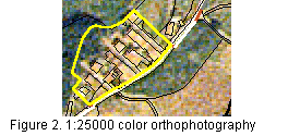
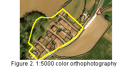
For cases where the available cartography is insufficient, 1:10000 color flight photograms of the Natural Park, corresponding to July 1993, have been orthocorrected. Color orthophotographs with 0.5 m spatial resolution were obtained from these photograms, and they offer an excellent level of detail. Figures 2 and 3 illustrate the difference in detail between the 1:25000 color orthophotographs (2.5 m spatial resolution) and the orthophotographs generated from the 1993 flight (0.5 m resolution).
 |
 |
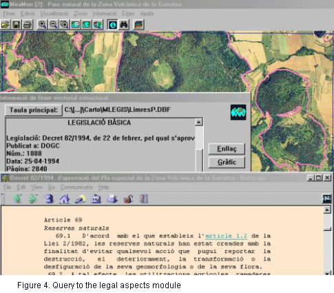
Once the limits of planning have been digitized and correctly structured, a new field is created in the database. Each register of each graphical element, specifies the HTML site containing the article(s) regulating it. Figure 4 shows how a query by location on a point in the territory takes us to the article regulating the area. The graphical element "knows", thanks to a database field, which is the regulation assigne to it. The GIS directly links us to the corresponding article with the help of a conventional Internet navigator.