Park Management
Fauna Management
Outline
One of the aspects of fauna management in the Natural Park is the program for monitoring vertebrates in the 'Zona Volcŕnica de la Garrotxa'. This program, undertaken with assessment from the company Minuartia, SL, breaks down into different monitoring subprograms for different groups of vertebrates or for particular species (amphibians, birds, rabbit, etc.). Vulcanus offers a GIS and database management system environment aimed at querying all the information generated by these monitoring programs. By means of the fauna database (Figures 1 and 2) different maps can be generated on species distribution, spatial ditribution of observations, activity of individuals (roe-deer), etc.
In regard to invertebrates corresponding to the fauna management module, there is also a catalog of invertebrates compiled by Jordi Nebot that can be accessed from the corresponding digital cartography page.
Goal and objectives
The goal of this module is to make available to Natural Park personnel a graphical and alphanumerical database for managing all the information related to fauna and generated by the different monitoring studies done by the Natural Park.
The objectives to be attained are:
Design and Implementation
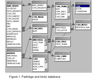
Figure 1 shows the tables and lists corresponding to the part of the database corresponding to the monitoring programs for birds and partridge. Apart from these two programs, the database also has tables and lists for general data on vertebrates observations, observations of roe deer, transects of rabbit, transects of mammals, electric fishing and amphibians.
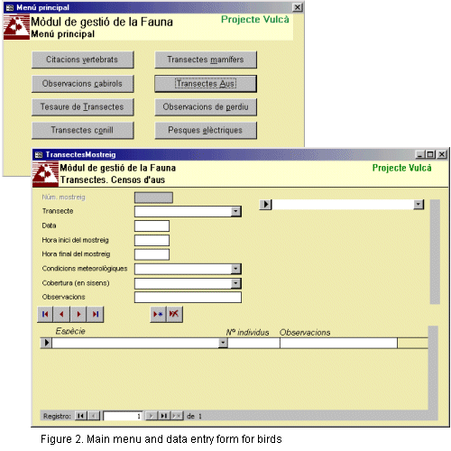
This database is supplied with data from fieldwork done by different study teams in each group. Data is entered using different forms of data for each monitoring study. Figure 2 shows the main menu and the form for maintaining the database corresponding to birds.
Using this database, any kind of map can be generated by querying the database, because the database contains the UTM coordinates for each sighting. In the case of sightings during a transect, the database contains the exact location of the sighting in the transect.
For examples of maps that can be generated from the database, see Figures 3, 4 and 5. Figure 3 shows the sightings of roe deer taken by radiotracking in the program for reintroducing roe deer into the 'Zona Volcŕnica de la Garrotxa'.
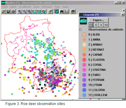
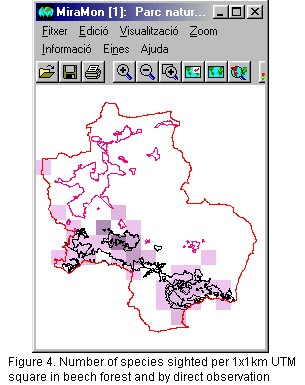
Figure 4 shows a map that gives us the number of species found by 1x1 km UTM square that meets the condition of having been sighted in a beechwood area and by direct observation. Even though the legend here is not shown, the boxes in darker purple indicate a greater number of observations, and the lighter purple ones indicate a smaller number of observations. (Vector) polygons bordered in black correspond to beechwoods as in the Park's vegetation map. Discrepancies between the vegetation map and some UTM quadrants that do not seem to be located in the beechwood area may be due to scale effects. That means that the person who made the observation was probably in a very small patch of beechwood that is not reflected in the vegetation map, and since the quadrant is a 1x1 square kilometers, it gives us a much broader area than the precise observation point.
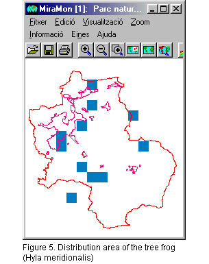
Figure 5 shows us the distribution area of the tree frog, Hyla meridionalis in the 'Zona Volcŕnica de la Garrotxa'. It must be kept in mind that this distribution area is based on observations referred to 1x1 km UTM squares, and with the set of data that was available at the time the map was made. We should not interpret these results as a real area of distribution for the tree frog within the Natural Park, but rather as an estimate based on the level of knowledge we have at a particular point in time.
|
|