Park Management
Water Quality and Quantity Control
Outline
The 'Zona Volcŕnica de la Garrotxa' Natural Park has carried out a program for monitoring the hydrogeological system of the area since 1994. The technical aspects of this program are led by the External Geodynamic and Hydrogeology Unit of the Department of Geology at the Autonomous University of Barcelona. The program also receives collaboration from the Garrotxa Polyvalent Laboratory and the Catalonian Water Agency. In order to make this monitoring study, a set of control points (wells and springs) located over the alluvial-volcanic aquifer were selected. This study is limited to monitorin only this aquifer, which is the most significant one in the area, and therefore does not take into account the aquifer in eocenic materials.
A total of about eighty points are monitored by taking water samples and measuring the water table depth during diffent sampling campaigns. During the first years, four annual sampling campaigns were carried out. Currently there are two sampling campaigns per yera. Water table depths are measured and water samples taken by the Park itself, while analyses are carried out by different laboratories, including the Autonomous University of Barcelona and the Garrotxa Polyvalent Laboratory.
The management problem Vulcanus faced was to develop a specific module for following up the database related to the aquifer. The goal of this module was to maintain the database, provide access to information about the point --construction characteristics, ownership, etc.-- and on measurements taken at each point. The module also had to let you create variation graphs for the different parameters measured at each well and maps of spatial variability for each considered water-quality parameter. Moreover, it had to let you make small reports for each well automatically.
Goal and objectives
The goal of this module is to integrate within the GIS the monitoring program for the hydrogeological system of the 'Zona Volcŕnica de la Garrotxa' so that Natural Park managers could organize, query and analyze its data.
The objectives to be reached are:
Design and Implementation
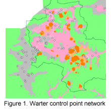
Figure 1 shows the points which make the network of control points. For each point there is a file with a description of it (depth, construction, owner, etc.) and a series of associated measurements (water table depths and hydrochemical parameters (nitrates, nitrites, electrical conductivity and ammonium)).
Green areas correspond to eocenic materials, the aquifer of which is not included in the study. This is why all points are situated in non-green areas, that is in the areas of the alluvial-volcanic aquifer.
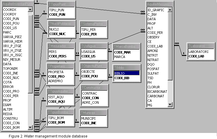
The alphanumerical part of the module, the database with descriptions of the points and the measurements taken (see Figure 2), is linked to the graphical part by means of a univocal code identifying each point. In this case, there is a relationship, one-to-many between the graphical elements, the points, and database records. Since various samplings have been carried out at each control point, each of these is linked to diverse records in the database.
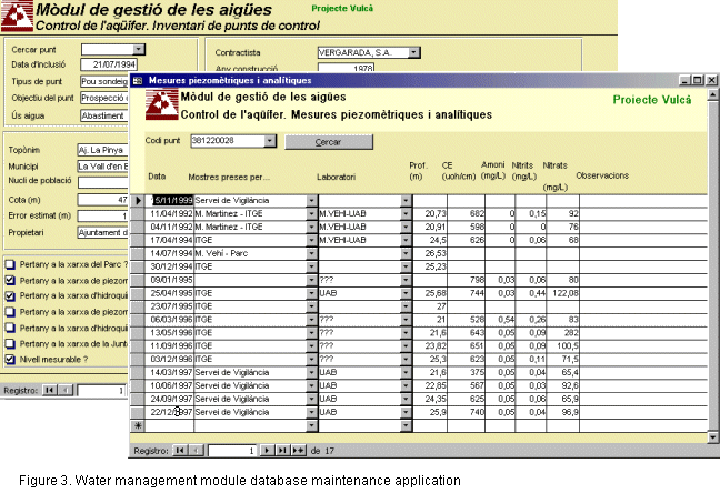
An application was created, using specific forms (see Figure 3), for water module database maintenance, data entry and editing. Once samplings are taken, this form helps the Natural Park staff to enter this data. Once the data has been entered, it is linked to the graphical part of the module, or rather, the layer of structured points representing the wells and springs selected to monitor the hydrogeological system.
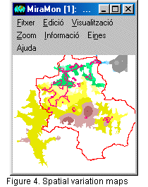
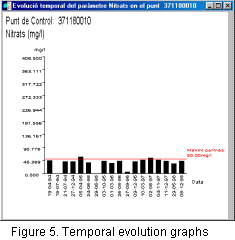
Figures 4 and 5 show two module products. On the one hand, through interpolation of the values from a specific sampling and corresponding to one of the parameters measured, spatial variation maps of the parameter are made for each sampling campaign. These maps give a general broad view of the status of the hydrogeological system for a certain parameter and a certain sampling. Interpolation may be done directly from the values stored in the database, just by telling the program what field (parameter) to interpolate and with which data. In order to perform this interpolation, there is a point interpolator specifically developed and available through MiraMon.The results are spatial variation raster maps that can then be reclassified with the layer calculator/reclassifier in order to obtain the final categories desired. On the other hand, you can make time evolution graphs for any parameter at any point, as shown in Figure 5.
 |
 |