Publications
In this section several publications on Vulcanus are presented. For further information please visit the Park's Documentation Center, see the thematic list on documentation recommended by the Natural Park, or directly contact the Documentation Center at wcdpnzvg@correu.gencat.es. Adreça del Centre de documentació: Parque Natural de la Zona Volcánica de la Garrotxa, Av. Sta. Coloma s/n (17800 OLOT), Spain. Telf: +34 972 26.46.66 Fax: +34 972 26.55.67
Nota: The articles presented in this section of the CD-ROM are in their original language, as they were published. None has been translated except for the below article about Vulcanus.
How to reference this article: Marcer, Arnald; Pons, Xavier; Vicens, Jaume. "El projecte Vulcŕ. Un Sistema d'Informació Geogrŕfica integrat a la gestió del Parc natural de la Zona Volcŕnica de la Garrotxa," in Cončixer per Conservar. Barcelona: Institució Catalana d'Histňria Natural. Nota: In press.
The Vulcanus Project. A Geographic Information System for the Management of the Natural Park of the Volcanic Zone of la Garrotxa.
Arnald Marcer1 (
Xavier Pons1,2 (x.pons@uab.es)
Jaume Vicens3 (wjvicens@correu.gencat.es)
1CREAF. Autonomous University of Barcelona. 08193 Bellaterra.
2Department of Geography. Autonomous University of Barcelona. 08193 Bellaterra.
3Natural Park of the Volcanic Zone of la Garrotxa. Department of the Environment.
Generalitat de Catalunya. Casal dels Volcans. Av. Sta. Coloma, s/n. 17800 Olot.
Abstract
Vulcanus is the information technology system aimed at helping the management and planning of the Natural Park of the Volcanic Zone of La Garroxa (equivalent to category V of IUCN). It is a Geographical Information System based on the MiraMon software package. The project represents a pioneer experience, in the context of Catalonia (Spain), in the implementation of these type of systems to protected areas and integrated in the workflow of an organization (the Natural Park, in this case). Vulcanus is formed by a set of data, computer tools and procedures to handle more than 2 Gb of information on the Natural Park. It is an open and decentralized system based on the park's Local Area Network of computers which also uses Internet technology to provide an easy access to data and information. Vulcanus integrates all environmental management issues of the Park (geology, soil, water, forests, vegetation, flora, fauna, hunting, public use and legal aspects) to apply them to the management and planning of rural improvement, natural heritage and public use at a 1:5000 scale.
Resum
Vulcà és l'entorn informàtic d'ajut a la gestió i planificació del Parc natural de la Zona Volcànica de la Garrotxa. Es tracta d'un Sistema d'Informació Geogràfica basat en el programari MiraMon. El projecte ha suposat una experiència pionera a Catalunya en la implantació d'aquests tipus de sistemes en àrees de dimensions reduïdes i integrades en el funcionament d'una organització (en aquest cas, l'equip gestor del Parc). Vulcà representa un conjunt de dades, eines informàtiques i procediments per a gestionar els més de 2Gb d'informació del Parc natural. Es tracta d'un sistema descentralitzat, basat en la xarxa d'ordinadors del Parc, obert i que utilitza la tecnologia d'Internet per a donar accés a les dades i la informació. Vulcà integra totes les temàtiques ambientals del Parc (geologia, sòls, aigües, boscos, vegetació, flora, fauna, caça, ús públic i aspectes legals) per aplicar-les en la planificació i gestió en l'àmbit de la millora rural, el patrimoni natural i l'ús públic a una escala de detall de 1:5000.
Resumen
Vulcano és el entorno informático de ayuda a la gestión y planificación del Parque natural de la Zona Volcánica de la Garrotxa. Se trata de un Sistema de Información Geográfica basado en el programa MiraMon. El proyecto ha supuesto una experiencia pionera en Cataluña en la implantación de este tipo de sistemas en áreas de dimensiones reducidas e integrado en el funcionamiento de una organización (en este caso, el equipo gestor del Parque). Vulcano representa un conjunto de datos, herramientas informáticas y procedimientos para gestionar los más de 2 Gb de información del Parque natural. Se trata de un sistema descentralizado, basado en la red de ordenadores del Parque, abierto y que utiliza la tecnología de Internet para dar acceso a los datos y la información. Vulcano integra todas las temáticas ambientales del Parque (geología, suelos, aguas, bosques, vegetación, flora, fauna, caza, uso público y aspectos legales) para aplicarlos en la planificación y gestión del ámbito de la mejora rural, el patrimonio natural y el uso público a una escala de detalle de 1:5000.
Introduction
Framework for the Vulcanus Agreement
Vulcanus is a computer application for assistance in managing and planning the Natural Park of the Volcanic Zone of La Garrotxa(Department of the Environment, 2000). This Geographic Information System (GIS), based on MiraMon programming (pons, 2000; creaf, 2000), sets the framework for managing Park data and information generated by studies carried out by the Park or through its management. The Vulcanus project was developed thanks to the initiative of the Department of the Environment (DMA) of the Generalitat de Catalunya and within the framework of a three-party agreement among this Department, the Cartographic Institute of Catalonia (ICC) and the Ecological and Forest Applications Research Center (CREAF). The project was a pioneering experience for Catalonia (Spain) in the implementation of these types of systems in small areas that are integrated in the workflow of an organization which, in this case, was the team managing the Natural Park (although later, similar initiatives were started up in the natural parks of Aiguamolls de l'Empordŕ, Sant Llorenç del Munt and Serra de l'Obac). Vulcanus began with a preliminary study in 1994, and initiated definitive implementation in 1995.
Vulcanus as a Management Tool
Vulcanus should be understood as a set of general computer tools that have been adapted to the particularities of Park management with their data and information related to the set of management areas within the Park and the protocols set up for proper processing of this data and information. This set of tools, data and procedures opens a window of opportunity onto queries, analysis and information production that is unprecedented in the history of the Park, not to mention in almost any protected area of Catalonia. This means that any study, whether it be done independently or sponsored by the Park, will have the opportunity of making in-depth studies of the area and making connections among sets of data that, until now, had been unclear or too loosely linked. The excellent set of spatial and alphanumerical databases and computer tools have made this possible.
Key Factors for Implementation
There are many alternatives when designing a GIS for an organization, and these alternatives depend on the characteristics of the organization itself, as well as the stated objectives. In the case of the Park and Vulcanus the option was for an open design based on the Park's Local Area Network (LAN). This lets software and data to be accessed from any of the Park's computers (therefore from any of the staff's desktop computers). Since the available computer tools are general and open any problem in information management can, in principle, be handled (Marcer&Pons, 1998; Marcer et al, 1998). These are not closed applications that let you do only reduced set of tasks just by clicking on the mouse. This design means that personnel require a higher level of knowledge. In this sense, emphasis is placed on teaching personnel about GIS concepts and training them in the use of computer tools.
This open design is also reflected in the organization of information and data. Both are distributed in a set of modules intended to respond to the different areas of Park management. Each module includes its own procedures and protocols for processing and using information, yet information is never duplicated, since the different modules can share necessary information (Marcer&Pons, 1998; Marcer et al, 1998).
It is also worth mentioning that Vulcanus uses Internet technology as a tool for making available to the management team any of Vulcanus's databases, documents or procedures. Likewise, the computer tools themselves, the MiraMon software, enable direct publication of Vulcanus' data in the Internet. This last point helps us underline the importance of keeping the new possibilities offered by technological advances open. Vulcanus started up in 1994, when the importance Internet would have began to be understood, but it has only been while the project was being executed that Vulcanus could be exported to the Internet. This point, which was not considered in the project's initial implementation document, indicates the need to retain a certain level of improvisation in order to adapt to new possibilities. We must not be restricted by an initial document which, even though it is essential, should serve only to indicate certain guidelines and strategies to be followed. The project must be allowed freedom of movement to head in a new direction.
Implementation Process
Implementation of Vulcanus in the Park was a gradual process from the time the first reference cartographic bases were installed and the directory structure designed to the moment when installation of software and data was complete and operating protocols were established. This process was also reflected on the gradual training of Park personnel on the use of Geographic Information Systems and, in particular, MiraMon. Responsibilities for coordination and execution were divided as follows. Project management was taken on by CREAF and the Park, execution was carried out by CREAF and evaluation was done through a commission made up of representatives of the Department of the Environment (Subdirectorate General of Studies, Natural Park and Directorate General of Natural Heritage and the Physical Environment), the Cartographic Institute of Catalonia and the Center for Ecological Research and Forestry Applications (Marcer&Pons, 1998). This commission met periodically throughout the duration of the project (about 3 times per year) in order to approve finished work and to decide on and approve new directions for the remaining work to be done. One of Vulcanus's keys to success was, in fact, this evaluation committee's ability to make decisions, and the firm support it showed the project.
Below we offer a brief review of the use of Vulcanus in the different areas of Park management and the possibilities it has opened for the future.
Integration of Vulcanus in Park Management
Vulcanus's modular design was a response to the differentiated management needs the Park has, which are carried out by management areas of its organigram. Each module is the responsibility of the corresponding management area. A synopsis is given below of Vulcanus's main, distinctive features for each of these modules.
Vulcanus: Geology, Soil and Water
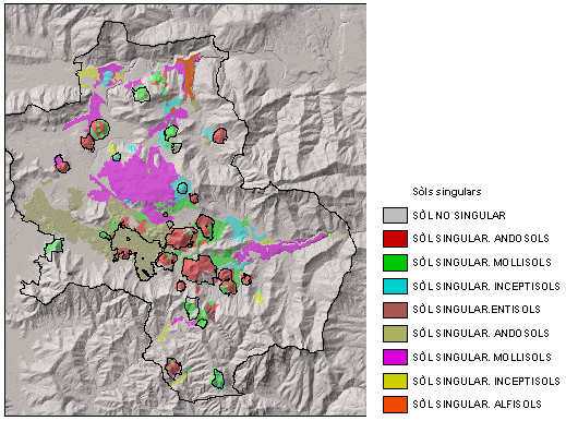
Within this area of management, there are three cases to which Vulcanus has given special consideration. On one hand, the update of the Park's volcanological map, which has already been made using the reference cartography available at Vulcanus, with the use of the MiraMon software tools. This map, in its digital form, has three graphical layers: lithology, geomorphology and geotechnics. All three are associated with the corresponding alphanumerical databases, which can be queried and derived layers extracted from them. Thus, for example, we can find out that the extension of basalt deposits in the Garrotxa volcanic area is 1044.6 ha, or that the length of all basaltic cliffs together is estimated at 54.8 km.
While the volcanological map was being made, the Park's soil map was also being made, and it was also made entirely within the framework of Vulcanus's possibilities. Vulcanus enabled cartography to be custom made for fieldwork, and to derive maps from the soils map, such as the Park's map of unique soils, the map of agrological capacity or the map of drainage capacity. Digital graphical bases are linked to an alphanumerical database and to a documentary database which characterize each type of soil. From the digital soil map we can access any type of associated data, such as its classification, its physical and chemical parameters or a detailed description of the cartographic unit in which it is framed. Also, the inventory of sampling points and associated data will be incorporated as a digital layer.
With regard to water, Vulcanus offers the opportunity to manage all data and maps derived from the environmental monitoring study on the hydrogeological system of the Park. Graphical layers, databases and procedures have been set up to handle the more than 80 checkpoints (wells and springs) and more than 1300 samples analyzed to date. This digital data can provide accurate monitoring on the quality and quantity of water in the area's alluvial-volcanic aquifer. There are computer tools to enter and maintain data in the database, analyze the condition of the aquifer by means of graphs of temporal monitoring of the main parameters that are measured and to use interpolation procedures to make maps indicating the spatial variation of the parameters: for example, nitrate concentration. Reports can also be made automatically on sampling wells in order to give them to their owners. Different spatial variation maps for the different parameters measured can be combined to make maps, using GIS analysis procedures, which indicate the spatial variation of the potability of the waters.
Vulcanus: Forests, Vegetation and Plants
Two especially relevant areas within this area of management are the Park's forest inventory and the vegetation map.
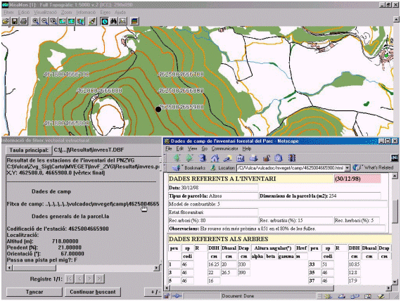
Vulcanus has enabled integration of the forest inventories carried out by the Park for different purposes: forest monitoring, reports on forest use and Technical Plans for Forest Management and Improvement (Marcer et al, 1999). Using the computer tools made available to the staff and the established procedures and standardization of field methodology, the above three tasks can be combined and allow inventories made for one purpose to be useful to the other two, and vice-versa. This enables to monitor the status of the Park's forests and to make reports and Technical Plans based on the same sampled plots. Monitoring the Park's forests evolution is also fed by the plots done for the other two purposes. This has given the Park a digital database of about 700 plots (as of May, 2000) which is conveniently enlarged with random sampling techniques and taking into consideration the level of variation in the data, so as to discern whether it is necessary to continue sampling or not. As in the previous cases, having excellent reference cartography available lets you make maps specifically tailored for fieldwork so as to place the plots as correctly as possible in the field.
The data from the Forest and Ecological Inventory of Catalonia and from the "Second National Forest Inventory" are also integrated in Vulcanus, allowing the Park's own data to be complemented and extending the available forest information to the entire county.
The Park's vegetation map was done entirely using digital procedures with Vulcanus's tools. An accurate and extensive task of on-screen photointerpretation has been complemented with extensive field work done with maps printed from the available digital cartography. The vegetation map in digital format has three graphical layers of information: the layer of vegetation polygons, the layer of characterization of borders between the different pockets of vegetation and the layer of vegetation of linear character (at the given scale) such as agricultural field borders or small irrigation ditches. The digital vegetation map, with a minimum polygon of 500 square meters, is complemented by a precise database of flora inventories which consists of more than 150 sampled points. Vulcanus can be used to perform any type of spatial analyses on these layers and derive new layers from them as necessary (for example, holm-oak wood distribution in the Park). On the other hand, the Park's flora catalog, thanks to its design and specially-developed software, is fully integrated in Vulcanus.
Vulcanus: Fauna and Hunting
This module includes all the park's monitoring programs of different animal groups (rabbit, partridge, butterflies, etc.), the vertebrate catalog and other studies. Vulcanus provides the organizational framework for all this data in the form of a relational database, and enables derivation of a series of graphical layers linked to the monitoring data. Furthermore, within the framework of Vulcanus and in collaboration with the different authors of the data, standards are set up for these, and specific applications, or forms, are developed to allow data entry for the different studies.
The availability of computer tools and the proper organization of information on conservation and natural resources also permits the incorporation in digital form of old documents that were not originally meant for digital media. This is the case of the Park's fauna catalog, which was converted, using specifically developed software, into a database that can be queried from the GIS.
Vulcanus: Legal Aspects, Reports and Cadastre
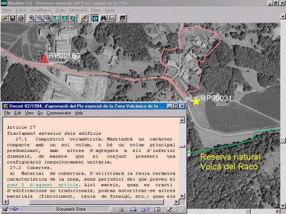
This area is central to Park management. Legal aspects define the standard for protecting the volcanic area, and they have clear, direct representation in the territory. On the other hand, one of the Park's main jobs is to write up reports on the many activities carried out in its jurisdiction. This job represents a considerable percentage of the total volume of work in the Park in one year. At the same time, writing up reports on activities means there must be a previous analysis of the different datasets in order to define if and to what extent the activity affects conservation in the area. It is in this integrated analysis aspect that Vulcanus is strongest, given its capacity to integrate diverse spatial information. The GIS lets us have graphical layers for the different areas of protection or regulation, and to access from these same digital graphical layers the texts of the articles defining the regulation or protection. We can, for example, click with the mouse on a natural reserve and access the legislation regulating it. This possibility has been extended to urban planning in the different districts that make up the Park.
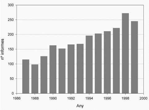
From 1999 on, the Park has a design and implementation for report handling within the Parks framework of operation, determined by procedures of ISO 9002/94, the quality control system applied to Park management. Vulcanus, in this case, has adhered to ISO 9002/94 indications and contributed solutions for quick management, consultation and analysis of all information related to Park reports. The Park's digital report map enables access from GIS to any report made by the Park, to its data, to the written report and map made, as well as to the history of the reported activity or use. So we can now answer questions such as how many favorable or unfavorable reports have been issued between such and such a date for this area of the Park and related to forests? On the other hand, Vulcanus has in this regard meant a very considerable reduction in the amount of time needed to complete a report. The design and implementation of report management has been extended to incorporate sanctions and projects done by the Park (studies, road maintenance, etc.), so that queries and possibilities of managing the aforementioned information for reports are now possible in making sanctions, projects and all actions provided for in the Park's Action Program (Marcer et al, 2000).
Cadastral information is also essential in managing protected areas. In fact, knowing the type of property in each part of the territory is of vital importance in managing it. In this regard, Vulcanus has provided the Park with the cadastral base of its territory in digital format. These bases enable to study the fragmentation of property and of priority protection areas, enabling to accurately define policies and strategies for conservation. It also provides quick access to knowledge on property, which is something that is often required on a daily basis.
Vulcanus: Public Use
One type of very important information for public use of the Park is the paths and roads network. Which are the main paths of the park, is a path is public or private, etc. The inventory of Park paths was designe from its conception as a consultable digital graphical layer. Therefore, now a graphical base is available with over 500 km of roads, in which queries can be made for any segment: is the segment public or private, which functional category is assigned to it. There is no need to mention the importance of this database in managing public access to the different areas of the Park.
Figure 4.
Vulcanus also lets you incorporate and query data corresponding to Park visitors which has been collected in its information centers.
Vulcanus as a Tool for Analyzing the Territory. Vulcanus's Future.
We feel that Vulcanus's years of experience demonstrate that it truly is possible, given the technology and current level of expertise, to implement a GIS for territorial management in organizations such as protected areas. These systems can be implemented, furthermore, not as centralized systems under the protection of a competent department or section, but also as open, decentralized systems based on LAN networks and accessible from any computer within the organization. We have also shown that implementing a system with these characteristics as a tool to assist the management team and to make data accessible to the general public can be done without in one single effort. There is no need for these two objectives to follow separate roads and have differentiated efforts.
The Natural Park of the Volcanic Zone of La Garrotxa currently has a very extensive digital database of over 2Gb and the necessary computer tools to query and analyze the information in it contained. One of the most fruitful tasks in the near future will doubtlessly be the interrelated analysis of data from the different aforementioned modules. Currently, questions such as what is the best site for a certain piece of equipment? what is the environmental impact of route N-260? what is the evolution of the Park's forests and how does it vary throughout the territory according to various environmental variables? can be answered. Park personnel are also beginning to be able to ask these questions and to start the process of obtaining the answers.
Most important, the biggest and costiest effort building Vulcanus has already been made: the initial drive, development of technology, structuring and organization of the databases, integration of the system in the organigram of Park operation and the training of personnel. It is from this point on that Vulcanus' potential for analysis and interrelation of data must open up and be able to help in new studies to gain more in-depth knowledge of the natural heritage of the volcanic area.
Vulcanus, Internet and Publishing Data in Digital Format
Vulcanus has advanced along two lines that enable data to be directly published in Internet or through any other digital media (CD-ROM, DVD, etc.). On the one hand, and as a main part, there is a tool for certifying and publishing digital maps, which lets you generate compressed and certified versions of Vulcanus's digital maps in a very simple and easy way. Once the maps are done they can be made accessible from a Web site. This possibility has already been implemented by the Department of the Environment by means of their Web page corresponding to the Environmental Information System of the Generalitat de Catalunya (Department of the Environment, 1999). This is based on the "MiraMon Map Reader", a public tool for accessing MiraMon certified maps (Pons i Masó, 2000; Creaf, 2000). On the other hand, a system has been designed and implemented for querying Vulcanus databases through the Internet. This way, the Park currently has the capacity to make public part or all of its data. This technology has also been used to publish the data included in this CD-ROM.
Acknowledgements
The authors of this article wish to express their gratitude for the invaluable support received from the three institutions that signed the Vulcanus Agreement. Without the initiative and support of the Department of the Environment, the excellent digital cartography lent by the Cartographic Institute of Catalonia and the expertise of the Ecological and Forest Applications Research Center, Vulcanus would not have been possible. It is very important to underline the fact that cooperation between governments and public institutions is a fundamental part of making this type of initiative become a reality.
We would also like to offer very special thanks to the many different people who directly or indirectly participated in carrying out this project, whom we cannot mention due to the risk of leaving someone out. To all of them, thank you very much.
Bibliografia
Creaf-Centre de Recerca Ecològica i Aplicacions Forestals. 2000. MiraMon.
http://www.creaf.uab.es/miramon/index.htmCreaf-Centre de Recerca Ecològica i Aplicacions forestals. 2000. Lector de Mapes de MiraMon.
http://www.creaf.uab.es/miramon/index.htmDepartament de Medi Ambient, 2000. El Projecte Vulcà.
http://www.gencat.es/mediamb/pnzvg/vulca.htmDepartament de medi ambient, 1999. SIG - Sistema d'informació Geogràfica.
http://www.gencat.es/mediamb/sig/sig.htmDepartament de Medi Ambient, Institut cartogràfic de Catalunya i Centre de Recerca Ecològica i Aplicacions Forestals. 1995. Conveni de col·laboració entre el Departament de Medi Ambient de la Generalitat de Catalunya, l'Institut Cartogràfic de Catalunya i el Centre de Recerca Ecològica i Aplicacions Forestals, per al desenvolupament del projecte Vulcà (Sistema d'informació geogràfica per a la gestió del Parc Natural de la Zona Volcànica de la Garrotxa)
Marcer, A., Pons, X. & Vicens, J. 2000. Design and Implementation of a GIS-based report management tool for the "Zona Volcànica de la Garrotxa" (Natural Park, Spain)". Proceedings of the XIXth ISPRS Congress Amsterdam 2000. En publicació.
Marcer, A., Ibáñez, J., Vayreda, J. & Pons, X. 1999. Aplicació dels SIG en la gestió forestal d'àrees protegides. A I Jornades sobre la Recerca en els sistemes naturals de Collserola: aplicacions a la gestió del Parc. Eds: Llimona, F., Espelta, J.M., Guix, J.L., Mateos, E., Rodríguez-Tejeiro, J.D. Patronat del Parc de Collserola.
Marcer, A., Pons, X., Vicens, J. & Falgarona, J. Noviembre 1998. Proyecto "Vulcà". Desarrollo de un Sistema de Información Geográfica para la gestión del Parque Natural de la "Zona Volcànica de la Garrotxa", Cataluña. Boletín de la Sección del Estado Español de Europarc. nş 8.
Marcer, A. & Pons, X. 1998. Park GIS Implementation. Proceedings of GIS laNET'98 International Conference and Exhibition on Geographic Information. 7-11 Setembre 1998. Lisboa - Portugal.
pons, X. 1994. Document del Departament de Medi Ambient sobre la Implementació d'aplicacions per al futur desenvolupament d'un sistema d'informació geogràfica al Parc natural de la Zona Volcànica de la Garrotxa. Document intern no publicat.
Pons, X. 1998. Manual del SIG MiraMon.
Pons, X. & Masó, J. 2000. MiraMon Map Reader, a new way for distributing and exploring Geographic Information. Proceedings of the XIXth ISPRS Congress Amsterdam 2000. En publicació.